LOCATION OF THE NATURE CONSERVANCY'S ECOLOGICAL PRESERVE, TRAIL SYSTEM, ADDITIONAL CONSERVATION LAND, AND DEVELOPMENT THREATS TO THE PRESERVE On November 25, The Nature Conservancy officially opened a 2 mile circular the trail system which it has constructed on its 350 acre ecological preserve. Highlights of the 2 mile circular trail are: 1. a "bog bridge" which permits visitors to access and observe an Atlantic white cedar swamp; and 2. views of giant rhododendrons located alongside Millstone Brook.
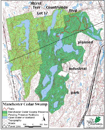
TNC has prepared a map which is shown here. The map's legend can be used to identify the boundaries of the original nature preserve (dark green). The properties shown in light green, identified as "pending purchase acquisitions" in the legend, have been recently authorized for purchase and/or annexation by the Board of Mayor and Aldermen as conservation land. The trail system itself is also shown (red line.)
The trail dedication ceremonies were reported in Manchester's two newspapers, the Union Leader and HippoPress. Unfortunately the articles failed to provide substantive information about the history of the conservation land arrangements. Both the donation of land to TNC by the City in 2001, as well as the authorization of additional adjoining conservation land parcels in 2002, came about via terms of a 1999 EPA/DES mandate or "Compliance Order" - that is, they occurred under substantial duress. Furthermore, the Compliance Order permitted the City to develop an industrial park directly adjacent to the nature preserve and it appeared that the City's co-operation in protecting the swamps was dependent upon this provision.
The TNC map shown here has been modified to show the location of the proposed industrial park southeast of the nature preserve. In some places, the area slated for development would lie within the swamps' small watershed. The TNC map should be compared with a 2000 Master Plan map which shows the "back to back" arrangement of the preserve and development areas.
The map has also been modified to show that the location of the TNC's trailhead is on Countryside Boulevard, a street which leads west from its intersection with Hackett Hill Road. The trailhead may be reached by driving or by taking public transportation. The Merrimack Valley Sierra Club held an outing to the nature preserve in May, 2002, when the trail construction was just beginning and the "bog bridge" had not yet been completed.
The location of another development threat to the nature preserve has also been added to the map. At the western end Countryside Boulevard there is a large retirement complex, Hillcrest Terrace, (Hlcrst Terr.) The area near the complex, titled "Lot 17"on the map, is an 18 acre lot which is located completely within the watershed of the Atlantic white cedar swamp complex. Manchester's Conservation Commission and Planning Board have recently approved the construction here of 29 single family homes by the Waterford Development Corporation. The construction is an adjunct to a massive residential development project which Waterford will undertake directly north of Countryside Boulevard and the nature preserve.
A brief explanation of the Waterford undertaking is given on the home page of this Web site, as well as a link to the details of the project and the manner in which its approval was obtained.
PERTINENT LINK
The NH Nature Conservancy has provided additional information about The Manchester Cedar Swamp Preserve on its own Web site.
HOME