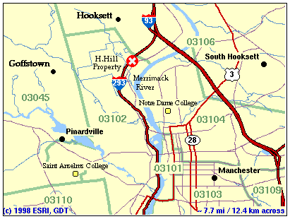
A map which shows the location of the Hackett Hill property in northwest Manchester is shown below.

* This map image is provided courtesy of ESRI and GDT.
From the South: Take Rt. 293 to Exit 7. Go north on Route 3A (Front Street) for 1.4 miles to Hackett Hill Road. Turn left and proceed along HH Road. At about .4 miles you will pass the former Hackett Hill campus of UNH-Manchester and French Hall, the only building ever constructed by UNH. Continue on to the intersection of Hackett Hill Road and Countryside Boulevard. Turn left on Countryside Boulevard and proceed west. The trailhead is located on the left, about .5 miles from the intersection. Park on the south side of Countryside Boulevard.
From the North: From Concord on I-93, do NOT take Hackett Hill Road exit at Hooksett tolls. Go through the toll booth. Take I-93 (NOT 293) and get off at Exit 10. Go left onto Route 3A (Front Street). Go ~.7 miles to Hackett Hill Road. Turn right and proceed along HH Road.At about .4 miles you will pass the former Hackett Hill campus of UNH-Manchester and French Hall, the only building ever constructed by UNH. Continue on to the intersection of Hackett Hill Road and Countryside Boulevard. Turn left onto Countryside Boulevard and proceed west. The trailhead is located on the left, about .5 miles from the intersection. Park on the south side of Countryside Boulevard.
Detailed information about taking a bus to the Hackett Hill area can be obtained at the Manchester Transit Authority Web Site. A visit to Hackett Hill's surroundings via public transportation definitely demonstrates environmental responsibility. The energy consumption and CO2 required for the trip is better justified since you and your fellow passengers share a single vehicle.
The MTA's Web Site map shows the route - Route 11 (Front Street/Hackett Hill) from the downtown Manchester starting point at Veterans Park on Elm St. to Countryside Village, an apartment complex north of the Hackett Hill property. The map also shows scheduled stopping points along the way. Busses return along basically the same route and complete the trip at the Center of NH, which is directly across Elm St. from the starting point.
The MTA Web Site also includes a detailed schedule. The schedule gives the times of departure from downtown, (12 trips per day) and the time of arrival at the various stops along the route.