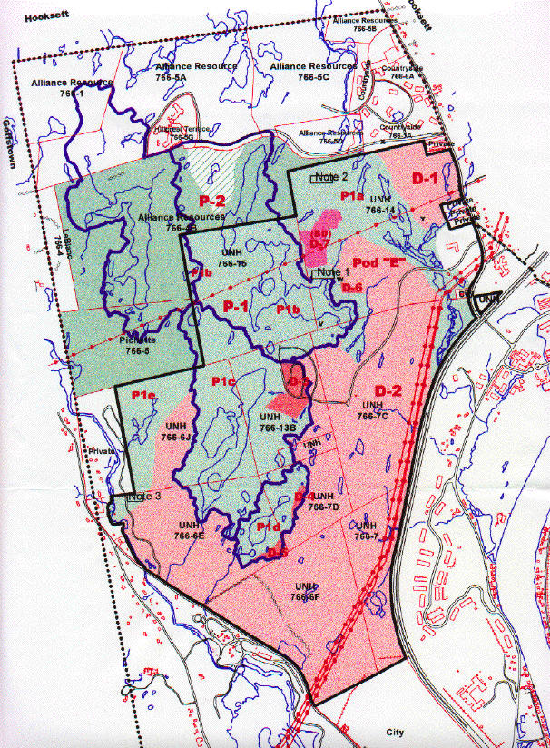
HACKETT HILL PRESERVE-DEVELOPMENT MAP Note: In the remainder of Part II of the Hackett Hill topic, there are several instances where a click on a "hypertexted" word or phrase will return the reader to a portion of Part I. These Part I sections help the reader to recall certain pertinent background information. After the Part I information has been read, click on the browser "back button" to return to Part II.
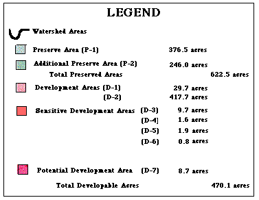
The Preserve-Development map (which will require significant download time) shows the Hackett Hill Property (the P1a-e, D1, and D2 areas of the map), and several abutting properties to its north. The legend beneath the map should be used to locate those areas on the property which are slated to be"preserved" (shades of green) and those areas which can be "developed" (shades of pink or orange). The acreage of each of these areas is also given.
Before one examines the Preserve-Development map, it may be helpful first to reexamine a map showing the Location of the Hackett Hill Property in NW Manchester and a Wetlands Map of the Hackett Hill Property. The latter map identifies the various types of wetlands located on the property. It also provides the complete outline of the abandoned roads and "phantom parking lot" complex built by UNH in the 1970s.
On the "Preserve-Development Map", the boundaries of wetlands are outlined by thin blue lines. The boundaries of watersheds are outlined by thick dark blue lines.
Map Interpretation Until the Preserve-Development Map became available, the exact proximity of the unique natural communities on the Hackett Hill property to any planned development was unknown to the public. Information released up to that time promised that the highly-valued wetlands would be "protected", but indications were also given that development was likely to occur on parts of the abandoned UNH road-parking lot complex. When scientists familiar with the natural history of the Hackett Hill property learned of this possibility, they strongly advised against any construction in this area.
The Preserve-Development map and its legend showed that two large portions of the Hackett Hill property had been set aside for development. These areas, D1 and D2 ( Development Areas), constitute 447.4 acres.
The map also showed that there is a 'Preserve" portion of the property, i.e., parts (P1 a-e) that totals 376.5 acres. Amazingly, four "Sensitive Development Areas" and one "Potential Development Area" appear as islands within this region. These areas (D3-D7) range in size from .8 to 9.4 acres and total 22.7 acres.
One of these areas (D3) is associated with the parking lot-road complex. Thus warnings to avoid development in this area were completely disregarded. Furthermore, the development that is planned for areas D4-D7 is likely to prove even more inappropriate. These development areas are situated in close proximity to the most highly-valued swamps. Not only will they involve the construction of buildings and parking lots, but they will also require the building of additional roads into the Preserve, or directly adjacent to it.
To fully comprehend the significance of the above plans, each of the five "Special or Potential Development Areas" should be considered separately. A list of these areas is shown below. Click on the name of each item in the list to learn: (a) the proximity of the planned development area(s) to specific wetlands; (b) the value of the natural communities found in these wetlands; and (c) how development could cause harm to these natural features. (Much of the information provided here has been derived from published references . These documents contain studies of the property which were conducted during 1995 and 1998 by UNH interns and during 1993 by Jon Nute, Forester, UNH Extension Service.)
"Potential or Sensitive Development Areas" 1. Preserve Area P1c Showing "Sensitive Development Area D3"
3. Preserve Area P1d Showing "Sensitive Development Areas 4 and 5"
BACK TO SUMMARY FOR PART II FORWARD TO EPA COMPLIANCE ORDER HOME