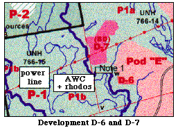
2. Preserve Areas P1a and P1b Showing "Potential Development Area D7" and "Sensitive Development Area D6"

a. Proximity of Development Areas to a Specific Wetland Preserve Area P1b is actually the watershed of a large Atlantic white cedar/giant rhododendron swamp (labeled AWC + rhodos). The area to the northeast of this watershed is identified as Preserve Area P1a. The swamp itself is outlined by a thin light-blue line. Its watershed (which extends into Preserve Area P2 - land located beyond the Hackett Hill property boundary) - is outlined by a thick dark-blue line. A power line (labeled) cuts across the swamp. The power line is owned by the Public Service Company of New Hampshire (PSNH).
The development-slated areas of this highly important section of the Preserve - "Potential Development Area D7" and "Sensitive Development Area D6" - are shown in dark pink and dark orange, respectively. D-7 is 8.7 acres in size, and is nearly bisected by the PSNH power line. D-6 is 0.8 acres in size. Both areas are located just outside the boundary of the Atlantic White Cedar swamp watershed. They are therefore nearly adjacent to both the cedars and the giant rhododendrons (which are located only at the periphery of the cedar stand).
b. Significance of the Atlantic White Cedar/Giant Rhododendron Swamp The Atlantic White Cedar/Giant Rhododendron swamp is probably the best known and most highly-prized of the forested wetlands on Hackett Hill. The swamp itself is ranked near the top of the 20 AWC swamps remaining in New Hampshire, and the AWC-giant rhododendron association is not seen anywhere else north of Connecticut.
This swamp is located in a kettle-shaped basin with a bedrock base. The water input for this wetland consists primarily of precipitation and ground water. There is a single stream which exits the swamp from the north and empties into Millstone Brook.
This swamp was ranked high in several of the evaluative criteria which comprise "The New Hampshire Method" for determining the worthiness of wetlands. These criteria were "visual quality", "high flood control potential", and "educational value." It was also ranked high in "noteworthiness". There are several reasons for its high rank in the last-named criterion: The swamp itself has a state designation of S3, which signifies rare/uncommon, and the giant rhododendrons have a state designation of S2, which signifies imperiled. In addition, it is a critical habitat for the swamp azalea, which is a state-listed species. Furthermore, this swamp is considered to be an appropriate site for scientific research.
c. Harm of Planned Development Importantly, a recent study, which produced highly significant quantitative data, was conducted within the AWC/Giant Rhododendron Swamp on a UNH wetlands field trip . These data indicate the extreme sensitivity of this swamp to any change in either the quality or quantity of its water supply. Clearly, such changes may be brought about by development in Areas D6 and D7 which lie very close to the watershed boundary of the swamp.
The existing "UNH road", shown in the lower right of the map section, does not reach these two areas. Presumably (a) new road system(s) would have to be constructed to reach them, causing additional disturbance to this portion of the property.