On November 2, 1998, 8 students who are enrolled in a "Field Wetland Ecology" course at UNH, Durham participated in a field trip to the Atlantic white cedar/giant rhododendron swamp on the Hackett Hill property. The swamp exists in a kettle-shaped basin of bedrock that has been filled with accumulating peat for thousands of years.
The students present were Lindsay Morrill, Matt Wood, Sandra Washburn, Jon Paul, Jason Demers, Jen Drociak, Jen Lessard and Bianca Mobius. They worked under the direction of their professor, Dr. David Burdick.
The objectives of the field work were for each team of 2-3 students to observe and record the general structure of the wetland; to characterize the vegetation in 2 sample sites, one at the "high" outer part of the swamp and one towards the "low" center; to take Eh and sediment cores in the two areas where plants had been sampled; and to measure the temperature, pH and dissolved oxygen in available water at the two sites.
Each team of students drew a sketch map of the area, chose 2 "sample" sites, and recorded these sites on their map. For each site, they identified all of the herbaceous species within a 1 m radius at the center. (If they were unable to identify a plant, a specimen was taken, placed in a plant press in order to preserve it, and brought back to the lab for identification). The abundance of the plants was recorded as the "% cover". Students then measured out a circular plot that had a 5m radius and identified and classified by height any saplings or shrubs found here. They also identified and counted all of the trees in the 5 m radius plot. Later, the students prepared lists of the three types of vegetation found at each of the two sites. In each case, they listed the dominant species first, followed by subdominants in decreasing importance.
For each sample site, students selected ten AWC trees that ranged in height from small saplings to one of the largest trees they could see. They next measured the height of each of these trees. In this photograph Dr. David Burdick observes as a student uses a clinometer - a handheld leveling device which works on a simple trigometric principle - to obtain data that concerns tree height. Also, for each of the ten trees on a site, a tape was used to determine the DBH (diameter at breast height). Later, students plotted the height of the trees versus tree diameter.
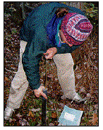
Water quality was determined from water found at each of the sites. Water samples were taken whenever open water was available. In the photograph shown at the right , data concerning water quality are collected from a substantial pool of water which was located at the base of a fallen tree. In all cases, the temperature, pH, and dissolved oxygen of the water were recorded.These data were later summarized in a table.
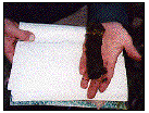
At each sample site, redox probes were inserted into the sediment in order to determine its redox potential . Sediment cores were also taken at each of the two sites, as shown in the photograph at the left, and the core was then extruded and examined. (see above photograph) Differences were noted in color, structure, and texture. A 10-20 centimeter piece of each core was placed in a plastic bag and brought back to the lab for bulk density determination following drying.
CONCLUSIONS
In their write-up of the Hackett Hill area, each team of students described the AWC swamp in general. They refined their original maps and added the locations of sites studied by all of the groups. The general area visited by the class was also shown on a formal map of the entire property. Students then described their methods and presented their organized data.
The students' assignment was next to analyze their various findings, and to draw CONCLUSIONS from them.