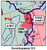
1. Preserve Area P1c Showing "Sensitive Development Area D3"
a. Proximity of the Development Area to A Specific Wetland Preserve area P1c is the watershed of a large Atlantic white cedar swamp (labeled AWC). UNH interns who studied the Hackett Hill wetlands in the spring of 1998 named this swamp the "Porcupine Swamp". The thin light-blue line signifies the swamp boundary. The thick dark-blue line signifies its watershed boundary.
The swamp watershed includes part of the abandoned system of roads and parking lots built during the 1970s by UNH. This cement complex is situated near the highest point on the Hackett Hill property. The swamp itself and the remainder of its watershed are situated downhill from the complex.
The planned "Sensitive Development Area" (D-3) , shown in orange, appears to fall on the parking lots proper. The appearance of the abandoned complex can be better visualized not only on the wetlands map.of the property, but also in photographs. The portion of the complex designated for development is clearly well-within the boundaries of the swamp watershed. It is intended to cover 9.7 acres. This area could be reached by the existing road which extends from the exterior of the property to the parking lots, so presumably a new road would not have to be constructed to reach it.
b. Significance of the "Porcupine" AWC Swamp Atlantic white cedars are located in the northernmost part of the "Porcupine Swamp", i.e., the part that is nearest the planned development. Towards the middle of the swamp there is a mix of black gum trees and red maple, and another stand of Atlantic white cedars is located in the southernmost portion of the swamp. Precipitation and ground water flow are two means by which water enters the swamp, but a stream of substantial size also emanates from the parking lot complex and carries water into the swamp. The outlet of the swamp is at its southern end and enters Black Brook.
The UNH interns (1998) used "The New Hampshire Method" for evaluating the worthiness of the forested wetlands included in their study. They ranked the "Porcupine Swamp" high in the following criteria: "visual quality", "high flood control potential", "educational value", "ground water use potential", and "wetland wildlife habitat". This swamp was also ranked high in the "noteworthiness" criterion, primarily because it is a critical habitat for swamp azaleas, and can be placed in a "least disturbed" category.
c. Harm of Planned Development Typically, any disturbance of portions of a swamp's watershed which are located upslope from it can be expected to have definite harmful effects on the swamp itself. This is especially so in this case, because very shallow soils and steep slopes are involved. The bedrock will serve as an impermeable layer and promote downward movement of water (and any development-associated contents) that has percolated through the thin soil.
For the reasons mentioned above, this development site has a particuly high impact potential. It is believed that it would be nearly impossible for development of this site not to alter the pristine environment of this "undisturbed" swamp.