Phase II of the Waterford Corporation's Countryside Boulevard project concerns the building of 3 sets of single family home "communities" at various points on the former "Optima Health" land. Two "communities" will lie north of Countryside Boulevard surrounding the Phase I luxury apartment complex. The third community is an area of major concern to environmentalists. It is slated to be built on the disputed Lot 17 which lies south of Countryside Boulevard.
The environmental significance of this particular lot can best be understood by first viewing a combination tax map and site plan map of the area and then a GIS map of the unique swamps on the HH property, and north/northwest of the property
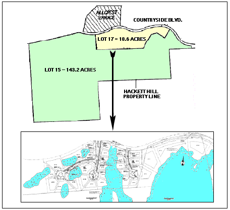
This figure shows a tax map of the boundaries of Lot 17 and an adjacent lot (Lot 15) both of which were originally owned by Manchester's two hospitals. While Lot 15, which is for the most part undevelopable, has recently been authorized for purchase by the City, it can be seen from the insert that Lot 17, which has 29 homes scheduled to be built on it, not only includes considerable wetlands areas, but the houses planned for it are in close proximity to finger-like protrusions of other larger wetlands. These protrusions are the northern end of swamps which are contiguous with the specialized swamps found on Lot 15. The Lot 15-located swamps, in turn, continue on to their counterparts on the Hackett Hill property's preserve.
The significance of this arrangement can be better seen by examining a GIS map of the area. A map of this type is shown below.
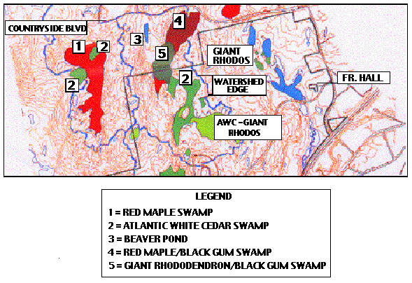
Here, it can be seen that the planned development will be in unbelievably close proximity to swamps that are for the most part directly contiguous with the well known Atlantic white cedar/giant rhododendron swamps on the Hackett Hill property, and that the houses will be within the same small watershed of all of these swamps. The swamp vegetation, which is adapted to the highly specialized conditions (low oxygen content, low nutrients, acidic peat moss substratum) and annual fluctuations in water quantity, is unlikely to survive the impact of continuous development-associated runoff from the nearby housing development. It is highly likely that the swamp complex will then by overrun by invasive species such as Phragmites.
Yet another view of the proximity of Lot 17 to the nature preserve owned by The Nature Conservancy can be seen on a map prepared by TNC.
In 1994, Sperduto and Ritter speculated that the 1989 development of Hillcrest Terrace and Countryside Village would have long-term impacts on the hydrology and water quality of this wetland basin. These investigators could hardly have imagined that in the future, unbelievable over-development would be planned in an area which is so closely adjacent to the swamp complex!
The giant rhododendron-black gum swamp whose location is shown on the GIS map, and lies in Lot 15, is an area of unusual beauty and the large quantity of rhododendrons seen in this area is truly amazing. Many of the giant rhododendrons, which have recently been recategorized as state-threatened, are found in a swamp which is seemingly several acres in size. Atlantic white cedar swamps are presently considered "rare" in their general location, which is along the eastern seaboard of the U.S. The reason for this classification is that only 10% of the swamps originally found here remain - the others have succumbed to the effects of nearby development projects.
The development threat has yet another aspect. Two endangered species are typically found in Atlantic white cedar swamps. They are Hessel's Hairstreak - a butterfly; and the Ringed Boghaunter (Banded Bog Skimmer) - a dragonfly. The larvae and pupae of the butterfly are located in the AWC treetops, but the adult butterfly sips nectar from a variety of flowering plants found near the AWCs. The dragonfly occurs in glacially-derived wetlands where spaghum moss is present. If the habitats of these species are disturbed by the development, a violation of the Endangered Species Act will occur.
b. Plans to Profit Financially from the "Hackett Hill" North Environment Both the EPA/DES and The Nature Conservancy, as well as the Sierra Club, feel that the 18.6 acre parcel of land known as "Lot 17" should be purchased by the City for conservation land, and serve as an extension of the Preserve. However the hospitals, developer and City have eyed it as a "cash cow." This lot is located directly adjacent to TNC's ecological preserve - and certain prospective homeowners are exected to pay an exorbitant amount of money to live in this location. Accordingly the City can then proceed to charge these property owners extremely high annual taxes.
As described previously on this Web site, to assure that this scheme would "work", an apparent "arrangement" between the hospitals, developer and City resulted in the rezoning of Lot 17 from R-S to R-SM so that a greater density of homes could be built there. (Subsequently, as a "compromise" move, the developer agreed to leave a portion of the lot zoned as R-S and promised to build a maximum of 40 homes on the 19 acres.) Although the selling price of the land to the developer is unknown, it is logical to assume that the developer will pay the hospitals an unusually high sum to obtain Lot 17.
Credits:1. The comments about the importance of protecting the AWC-rhododendron swamp were found in: Sperduto, DD., and Ritter, N., "Atlantic White Cedar Wetlands of New Hampshire." Prepared for the Environmental Protection Agency Watershed Protection Section-Region 1,Boston, MA (unpublished, 1994).
2. The tax map is a portion of a map discussed elsewhere on this Web site in connection with the sub-division of the Optima Health property.
3. The site plan insert is from the complete site plan for the single family homes. It was presented to the Manchester Planning Board by the Waterford Development Corp.
4. The GIS map is a portion of: "Figure 1 Hackett Hill Property and Piezometer Locations Manchester, NH" which appears in "The Relationship Between The Wetland Plant Communities and Hydrological Regime at Hackett Hill, Manchester, New Hampshire" by Kimberly P. Hall. (Submitted in 2002 to Antioch New England Graduate School in partial fulfillment for the requirements for the degree of Master of Science in Environmental Biology.) Ms. Hall is a Sierra Club member.
BACK TO OTHER TOPICS FOR:
HOME