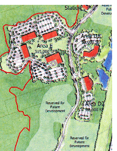
This development
stage consists of refurbishment of approximately 2000 feet of  existing drive, construction of
approximately 350 feet of new road, and construction of the 36.8 acre
development Area E. This work includes reconstruction of the storm
drainage system and enhanced landscaping along the main
roadway.
Area E consists of the "phantom parking lots"-road complex from a failed UNH expansion scheme in the 1970s. This site is approximately 36.8 acres in area, and includes portions of the property identified in the CSO agreement as "special development areas."
Actually the CSO agreement indicated that only a single "sensitive development area" would be located in Area E. This area, which was designated as "D3" on the inital "Preserve-Development" map, was in part within the watershed boundary of another Atlantic white cedar swamp. Development on the parking lots will be located uphill from both Atlantic white cedar swamps, increasing the likelihood that run-off from impermeable surfaces could do considerable damage to these forested wetlands.
As one of the largest development areas of the Hackett Hill property, Area E provides the opportunity to develop a campus style grouping of buildings clustered around a central open space, or a single large facility related to open space. The conceptual master plan indicates approximately 315,000 SF of building in this area.
The open space core of the campus development will provide another focal point for the development as one drives along the access drive.
As shown in the main stages map, the construction of Area E will complete development stages that will form a "horseshoe" around the Atlantic white cedar-giant rhododendron swamp.
The "drainage system reconstruction and enhanced landscaping" which will be done along the access road, will wipe out the interesting and picturesque natural communities which have formed here in the course of time.The new road construction will be extensive, expensive and destructive of a variety of wildlife habitats.
The manicured park-like setting will be in contrast to the wild, natural areas of the Preserve and the open space of the Park.
This is a ridiculous statement which "speaks for itself."
The building of Area E to supposedly make use of the existing "phantom parking lots" and access road can be considered as "building on past mistakes." This construction, which occurred nearly 3 decades ago, should be left "as is" so that it may serve as a reminder of previous ill-planned environmental degradation. Nevertheless, under the Sierra Club educational plan the road could serve as a means for conveying student groups into the interior of the property. Also, the parking lots could serve a starting point for field trips into the AWC swamps and upland forests, and possibly house a small inconspicuous shed for equipment storage.
Stage V consists of approximately 850 feet of roadway extension to service development areas D1 and D2. Work in this phase also includes preparation of the building pads for these development areas, comprising approximately 18.2 acres of buildable area.
Areas D1 and D2 like Area C, consist of 25.9 acre parcels along the steeply sloped east side of the existing access road. The high degree of difficulty of building on this site, as well as its likely provision of good views, as well as visibility from the F.E.Everett turnpike has already been mentioned with respect to Area C.
The D areas are located in a heavily forested area which at present contain no roads. The previous critique of the Area C construction plan also applies here, i.e., the "difficulty of building" and "good views and visibility from the turnpike" undoubtably will involve expensive leveling of cliffs and ledges, as well as extensive deforestation not only within the development areas but surrounding them.
It should be noted that vernal pool complexes are located in or near the D areas and conceivably these sensitive surroundings would be at high risk based on their proximity to roads and buildings.