AERIAL PHOTOGRAPHY OF HACKETT HILL - DEVELOPMENT WILL CAUSE EXTENSIVE DEFORESTATION The Hackett Hill Master Plan calls for a stage-wise series of "development areas" to appear. Most of the areas have been designated by letters, indicating the order in which they are slated to appear, i.e., A1-A3 and C in Stage II, B1-2 and a "Village Center" in Stage III, E in Stage IV, D1-2 in Stage V and F in Stage VI. (See Development Stages Map). In addition, roads are planned so that the various development areas can be accessed.
As shown by this map, although all of the development areas are located in the non-Preserve portion of the property, in several cases they will be situated in close proximity to Preserve-located Atlantic white cedar swamps. Also, one development area, Area F, is located relatively near a black gum swamp.
All of the planned development areas are presently heavily forested by a variety of hardwood and softwood trees such as oak, maple, hickory and pine. Many of the trees are over 100 years old. Since these trees are not afforded the protection of the Preserve, extensive tree-cutting will occur in order to establish the development areas and to allow roads to be built.
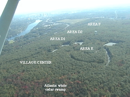
Aerial Photography of Forested Areas The heavily-forested nature of the intended development areas is difficult to appreciate from the ground. However in the aerial photograph which appears below, it is shown very dramatically. Certain landmarks can also be seen - the "Phantom Parking Lot"-road complex, the water tower, the Everett Turnpike, the Merrimack River and downtown Manchester. Manchester's landfill, which is closed, has a light green color in the photograph. A portion of an Atlantic white cedar-giant rhododendron swamp is also visible. The photograph was taken at a time when red maples and other hardwoods at the swamp's periphery were undergoing their annual color change.
The portion of the property appearing in the photograph is slated to contain several development areas, i.e., the "Village Center" (part of Stage III), Areas D1 and D2 (Stage V), Area E (Stage IV) and Area F (Stage VI). (See Development Stages Map.) The trees located in these areas will be replaced by buildings, parking lots, and landscaped lawns. More trees will disapear as the Access Road, which currently enters the parking lot complex near the intended "Village Center", is extended to pass directly adjacent to Areas D1, D2 and F and meet Dunbarton Road near the landfill. The 5 areas shown will result in over 100 acres being deforested (an acre is about the size of a football field.). Road building will result in additional deforestation.
The aerial photograph can be used as an "imagemap". Click on the name of a development area to link to the master plan drawings of the various buildings and roads. USE BACK BUTTON TO RETURN. (Note that the photograph was taken looking southward towards Manchester, whereas the development areas have been drawn as they would appear if one were looking towards the north.) The AWC link provides information about this important swamp community.
It is obvious that both the Village Center and Area E are located in close proximity to the Atlantic white cedar swamp shown in the picture, and the Development Stages Map shows that these areas are directly adjacent to the Preserve boundary. In fact, the swamp is described as being an "amenity" which will "increase the quality of life" for workers. Left unsaid is the likelihood that the sensitive swamp area will clearly be imperiled by the impacts of the development. Atlantic white cedars are especially susceptible to changes in the quality and quantity of the water they receive.
In the Master Plan, Areas D1,D2 and F are described as offering "good" or "great"views of downtown Manchester. It should be realized that extensive deforestation within and around the development areas will be necessary to achieve this effect. Unfortunately, people traveling north on the Everett Turnpike will see clusters of buildings on the hillside instead of the present uninterrupted greenbelt visible at the city's periphery.
Credits: The aerial photograph was taken by Don Welch.BACK TO INTRODUCTION