This stage of
development represents the largest single investment in the
development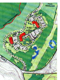 program. Once
Stage V development is completed, the construction of over 5,000 feet
of roadway is required to provide access to Dunbarton Road,and to
access the 35.6 acre development area F.
program. Once
Stage V development is completed, the construction of over 5,000 feet
of roadway is required to provide access to Dunbarton Road,and to
access the 35.6 acre development area F.
The development cost of the road is disproportionate to the amount of development area made available by it. The provision of a second access from Dunbarton Road, and the proposed new highway interchange will be needed to realize the full potential of the more northerly areas of the property, and to proceed with development of properties in excess of the existing Hackett Hill Road access.
The reference to disproportionately is "a masterpiece of understatement." A "proposed new highway interchange" is not in the present New Hampshire DOT 10 year plan and could not conceivably occur for at least 7 years.
Area F anchors the southerly portion of the development. This 35.6 acre site is another opportunity to develop a campus area of approximately 300,000 SF. Like Development Areas C + D, Area F lies on steep slopes to the south and east of the access drive. Development of this site will involve significant earthwork, but the buildings will likely have great views of downtown Manchester, and will provide a visual link to the City proper. A key component of this development area is the provision for another park-like setting along the road as in Area E, serving as a southerly reach of the access drive.
The previous criticisms regarding Area C and the D areas also apply to this "opportunity for development." The "park like setting" along the road apparently refers to the construction of yet another set of buildings and lawns which will be completely out of keeping with the natural surroundings in this "roadless" area.
It should be noted that the Preserve-Development map originally called for development areas to be located nearer the Black Gum swamp (see main stage map.) Although these areas have apparently been moved away from the BG swamp and further into the cliffed/ledged region, they are still in relatively close proximity to the swamp. Moreover a "Reserved for Future Development" zone exists between the Black Gum swamp and Dunbarton Road and the drainage area from the swamp, which is critical for its survival, passes directly through this area.