EARLY SPRING, 2005, CONSTRUCTION OF SINGLE-FAMILY HOMES ON "LOT 17" FOLLOWING EXTENSIVE BLASTING AND CLEAR-CUTTING
As noted previously the Manchester Planning Board gave its approval in December, 2001 and in October 2002 to the Waterford Development Corporation for an extensive two --phased residential development project on Hackett Hill in northwest Manchester.The second phase of the project was strongly opposed by the Sierra Club, which had proposed a year's moratorium on the development, primarily to permit studies which would determine; (l) what habitats would be affected directly by the development; and (2) any possible harmful effects of the development on The Nature Conservancy's ecological preserve. The biological data collected could have used to determine if at least part of the property concerned could be protected. Unfortunately, the Planning Board paid scant attention to the moratorium proposal and obviously favored the development project. (The archived information also notes that the blame for environmental damage done by the Waterford development must be shared with the Manchester Board of Mayor and Aldermen. The BMA voted to rezone part of the affected area in order to suit the developer's demands.)
As evaluated in the summer of 2005, the Waterford Development Corporation's Phase I (luxury apartments) and Phase II (single family homes) projects has caused extensive deforestation and habitat loss up. The land sold to Waterford by Manchester's two hospitals is located directly north/northwest of the Manchester Cedar Swamp Preserve. Most of the land undergoing development was heavily forested. It is closely adjacent to unspecialized or specialized wetlands, and formerly served as habitat for beaver, moose, deer, great blue heron, ladies slippers, and numerous other species. At least some of it should have been set aside as conservation land, instead of being used for residential development.
Land clearing for Phase I of the development - the construction of Waterford's luxury apartments - "Waterford Place" - got underway in the summer of 2002. Deer and various smaller mammals fled the activity, which took place north of Countryside Boulevard, and wildlife began to appear in yards of nearby homes. Construction of the 8 building apartment complex continued throughout the remainder of 2003 and during much of 2004 and appears to be nearly complete in 2005, with the loss of habitat becoming increasingly obvious.
In the late winter and spring of 2003, Waterford began the second phase of its residential development project - the construction of single family homes at the periphery of the apartment complex. As shown in the map-diagram below, the development is located: (1) on tax map Lot 8 which is located north of Countryside Boulevard and (2) on tax map lot 17 which is located south of Countryside Boulevard. The apartment complex is located in the center of Lot 8. Three "communities" of homes have been planned. Two of these communities will be located north and south of the western end of Countryside Boulevard on Lot 8 and Lot 17. The third "community" is located near the Hooksett line and borders on Hackett Hill Road.
NOTE THAT SEVERAL MORE DETAILED MAPS OF THE PLANNED DEVELOPMENT AND ITS RELATIONSHIP TO PROTECTED AREAS CAN BE FOND IN ARCHIVE F AND ITS LINKS.
DEVELOPMENT NORTH OF COUNTRYSIDE BOULEVARD Construction of the first set of homes community located directly to the north of Countryside Boulevard (on Lot 8) - "Woodland Ponds" - is nearing completion in 2005 (another set of homes in this same "community" will be built directly north of the first set). Numerous wetlands located on the Lot 8 property. Most of them are easily identified as abandoned or active beaver ponds, and do not resemble the protected, specialized swamps south of the roadway. They are characterized by scummy water and the presence of numerous dead or dying trees known as "snags" and an abundance of cattails.
Although the wetlands north of the roadway have a strikingly different appearance than Atlantic white cedar, rhododendron or black gum swamps, nevertheless, they are subject to protection by wetlands laws. Yet as Waterford proceeded with the construction of both phases of their development project, there has been a lack of compliance with these requirements. The wetlands violations are especially disturbing since approval of the Waterford projects was granted by the Manchester Planning Board with the stipulation that there would be periodic inspections of the development. This requirement was ignored as land clearing and construction activities got underway and proceeded through the summer and fall of 2003, until the complaints of concerned citizens brought about limited inspections and Waterford was called to task for its violations. The links below show stages in the construction of buildings north of Countryside Boulevard on Lot 8. They also explain how Waterford has shown little concern for the environment as this construction proceeded.
Apartment Construction Single Family Homes Construction Waterford's Agreements and Assurances Are Poor
DEVELOPMENT SOUTH OF COUNTRYSIDE BOULEVARD As noted previously, the community located south of Countryside Boulevard (on Lot 17) comes perilously close to the headwaters of swampland located in the Manchester Cedar Swamps Preserve, thus jeopardizing the integrity of the major swamp complex. The community is actually within the watershed ofthis complex. A giant rhododendron swamp is perilously close to the housing complexes.
Also, as noted previously, the development of Lot 17, which had been proposed as part of Manchester's mitigation land for the widening of I-93, came shortly after the EPA reversed its position on "secondary mitigation land" on Hackett Hill.
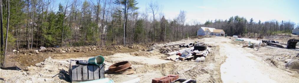
As shown in these photographs taken during the late winter of 2003-2004 - feller buncher and land clearing began to construct one of two cul-de-sacs for single family homes located south of Countryside Boulevard. This activity was followed by extensive blasting and road building duirng 2004 and eventually the building of houses began. The state of this cul-de-sac in May, 2005 is shown in the panoramic image at the top of the page.