WATERFORD CUTS
ITS 600 UNIT DEVELOPMENT PLAN BACK TO 487 UNITS AND FACES OPPOSITION
AT A DECEMBER 15, 2005 PLANNING BOARD MEETING
 On November 5,
2005, an article written by Mark Hayward, reporter for the Manchester
Union Leader, revealed that the latest Waterford Development project
had been reduced to 487 homes. Hayward noted that Robert Shapiro,
Waterford Executive Vice President, said the redesign is "geared to
the current market demand."
On November 5,
2005, an article written by Mark Hayward, reporter for the Manchester
Union Leader, revealed that the latest Waterford Development project
had been reduced to 487 homes. Hayward noted that Robert Shapiro,
Waterford Executive Vice President, said the redesign is "geared to
the current market demand."
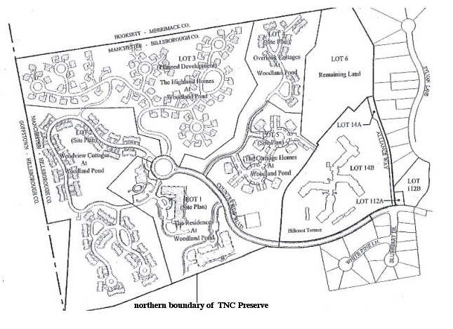
The general plan of the project,
known as "The Neighbors at Woodland Pond", is shown below in a
detailed map presented to the
Manchester Planning Board on December 15, 2005 at a public
hearing. (Return to the
"orientation map" and legend on the home page of this Web site to see the location of the proposed
development (#10 on the map) relative to other features of the
Hackett Hill area.) The complex application plan showed 150 luxury
condominiums in multistory buildings, 64 eight-plex garden-style
units, 198 townhouse-style units and 75 single family style
condominiums, as well as a central clubhouse. According to Hayward's
article,Waterford predicted the development will increase the City's
tax base by $153.88 million.
As seen on the detailed map, buildings
and roads occupy nearly all of the land that comprises Manchester Tax
Map Lot 16. The former owner, Alliance Resources (Catholic Medical
Center), retained possession of a small portion of the lot, titled
"Remaining Land" on the map. Not shown on the map is a massive water
tower that will be built on the property.
A new feature of the planned development is the
construction of an extension of Countryside Boulevard into the
property. As the map shows, the extension would separate Hillcrest
Terrace Retirement Community from part of Waterford's single family
homes "community" (note streets titled "White Pine Ln" and "Blueberry
Dr.") Also, part of the road extension will border on the Nature
Conservancy's ecological Preserve, and some of the buildings will be
very close to the TNC property line.
 Waterford's
presentation provoked numerous questions and comments by the Planning
Board and members of the public, and it was noted that several
letters had been received by the Planning Department and Planning
Board regarding the development.
Waterford's
presentation provoked numerous questions and comments by the Planning
Board and members of the public, and it was noted that several
letters had been received by the Planning Department and Planning
Board regarding the development.
Waterford had presented a Traffic Impact and Site
Access Study (TIAS) for the development. It can be noted on the
orientation
map that the planned development is at the
end of a traffic cul-de-sac (Countryside Boulevard) and that traffic
from all of Waterford's development projects, Hillcrest Terrace, and
Countryside Village (an apartment complex) must feed onto Countryside
Boulevard and then primarily to Route 3a via Hackett Hill Road. In
addition, Route 3a, which already has considerable traffic, will
shortly be receiving traffic from a giant Wal-Mart to be built just
north of the Manchester-Hooksett border.
A letter had been sent to the Manchester Planning
Department about this situation by Tim White, the Senior
Transportation planner for the Southern New Hampshire Planning
Commission. He felt that "the TIAS should be redesigned to produce
the information required for a full understanding of the impacts of
the proposed residential development on traffic in both Manchester
and Hooksett." A Hooksett city official also questioned traffic
considerations and requested that the Waterford hearing be left open,
that is, not voted upon, at the current meeting.
Others questioned other impacts that the
development project would have. Two abutters to the property, whose
homes are on Dunbarton Road in Goffstown, noted that their property
and lives would be adversely affected by the development. Todd
Connors, a member of the Planning Board, wanted further information
on how the developers planned to handle the likely development-caused
appearance and proliferance of invasive plant species, particularly
Phragmites - a concern since the development is located in such close
proximity to The Nature Conservancy's Preserve. He felt that the
conceptual schemes for the project should include areas that lie
north and south of the lot to be developed, and requested that this
information be presented at a subsequent meeting.
Pat Mattson, who represented the NH Sierra Club,
explained that the lot to be developed had very high ecological
value. She noted that it is an "animal corridor" connecting
undeveloped land to the north and south, and was thus highly prized
by environmentalists. It is likely that deer, moose and possibly
black bear presently make use of the land passage. She noted that the
lot was proposed by the EPA as a "secondary mitigation site" for the
widening of I-93, that the selection had been based on a study that
involved professional biologists from the NH Audubon Society, among
others, and that the Sierra Club and the NHDES had independently
recommended to the NH Department of Transportation that the lot be
chosen for mitigation. (Although the proposed secondary mitigation
did not occur, the environmental value of the land can nevertheless
not be questioned.)
 Mattson also
inquired as to what degree Waterford's development plans would affect
public access to the TNC Preserve. A large beaver pond and dam lie
within the Preserve near the development. Although the integrity of
the pond may be threatened by the impending development, at present
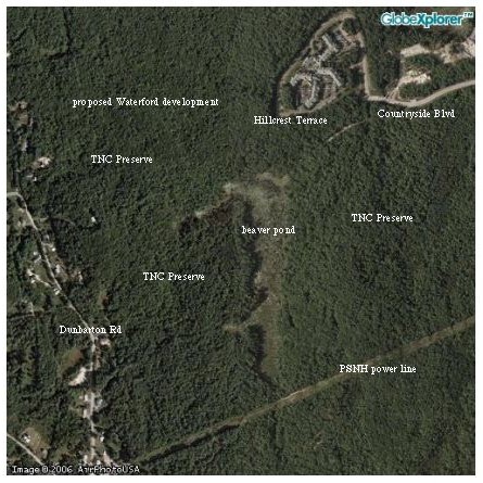
it is highly appropriate for environmental education. The aerial map that appears here shows the close proximity
of the beaver pond to the proposed building complex. (Compare with
detailed map above.) It is also possible to see Waterford's approved
development complexes-in-progress to the north and south of
Countryside Boulevard. Mr. Shapiro responded that "The Nature
Conservancy doesn't want people on its property."
Mattson also
inquired as to what degree Waterford's development plans would affect
public access to the TNC Preserve. A large beaver pond and dam lie
within the Preserve near the development. Although the integrity of
the pond may be threatened by the impending development, at present
it is highly appropriate for environmental education. The aerial map that appears here shows the close proximity
of the beaver pond to the proposed building complex. (Compare with
detailed map above.) It is also possible to see Waterford's approved
development complexes-in-progress to the north and south of
Countryside Boulevard. Mr. Shapiro responded that "The Nature
Conservancy doesn't want people on its property."
Importantly, the Planning Board also received a
letter from The Nature Conservancy about the Waterford plans. TNC had
several concerns. It was noted that private land owners, the City of
Manchester, the NHDES, and the U.S. EPA have worked together to
create the 600 acre preserve, and that the City of Manchester has
contributed $2 million dollars of the total $2.3 million that was
required, as part of its SEPP agreement. It was also noted that a
portion of the proposed development is in close proximity to the
Preserve and drains directly into the Manchester Cedar Swamp
Preserve.
TNC felt that comments about the development that
they submitted to Waterford in 2004 were not reflected in the current
subdivision plans. They noted there are "construction risks" since
the major road in the development is right along the TNC property
line. Also silt fencing and grading for the road appear to be planned
for the TNC property, and a retention pond and a four story building
are proposed to be constructed within a few dozen feet of the line.
TNC also felt there should be long range plans to monitor the
development for invasive plant species and that a natural buffer of
300 feet should separate development from conservation areas. They
also felt that the wetland buffers shown on the plan for the property
should be extended from 25 to 100 feet, and noted that all buffers
should be naturally vegetated areas.
*******
The Manchester Planning Board agreed that the
hearing for the Waterford project be left open. The application was
scheduled to be discussed next at a January 12, 2006 public meeting
of the Board.
HOME